Pages

Sunday, September 22, 2019

5 CTA Stations in Desperate Need of a Facelift

In keeping its "legacy" rail network intact, the CTA has rehabbed many rail stations handsomely over the past few decades. Which stations should be next?

Sheridan station on the Red Line. (Image: David Wilson/Flickr)

In recent decades, the Chicago Transit Authority (CTA) has heavily prioritized maintaining its sizable rail transit system over expanding it.

This approach makes sense: as one of few "legacy" urban rail systems in the United States, and one that expanded greatly over the course of a century-plus, there's a lot to maintain. The CTA's 146 rail stations are the second-most among US rapid transit systems, its 103 track miles the fourth-most.

The emphasis on maintenance has served the network well. A strong majority of stations across the system, and often the tracks that serve them, have been significantly rehabilitated within the past 30 years. More lines and stations are still to come.

Today, the system's overall performance, as well as some of the completed line and station reconstruction projects, are often cited as aspirational case studies in other cities. And with over 225 million riders in 2018 (the US' second-most), it's clear that amid flaws and limitations, the CTA's rail network continues to be an irreplaceable asset to city life in Chicago.

But again, there's a lot to maintain. Some branches and stations have been left behind. Some have improvement plans funded and ready to go, such as the north Red Line. Others have unfunded plans stuck on the drawing board, or no plans at all.

Let's take a look at a few of the neglected stations that could use a bump--we'll exclude those currently under rehab or funded for one soon.

State/Lake (Loop: Brown, Green, Orange, Pink, and Purple Lines)

Narrow platforms at State/Lake, the fifth-busiest CTA station by 2018 weekday ridership, serving five lines. (Image: Adam Moss)
None of the stations on this list are handicap-accessible. Even for those able to walk up 1895-vintage State/Lake's stairs, though, it is not unfair to label this station a safety hazard.

The main culprits here are two dangerously skinny platforms. The platform gets especially narrow (sometimes only one or two standees wide) near the entrance turnstiles, so rush hour crowds quickly become problematic. And as a prime station to access downtown attractions, there is often a good proportion of tourists and irregular riders to make things even more interesting.

The south/Inner Loop platform, which serves the Orange, Pink, and Purple lines, as well as 63rd St-bound Green Line trains, was expanded slightly in 2016 in somewhat of a spontaneous project in response to extreme crowding.

State/Lake is one of Chicago's iconic downtown "L" stations, although this is much more true in location and patronage than in practicality. (Image: Jim Pearson Photography)

Still, that limited expansion was a temporary fix, and ridership here has grown rapidly--a 36% increase between 2010 and 2018, to over 12,000 boardings per average weekday.

Recognizing the issue, the CTA announced in 2017 that it had received a federal engineering grant to begin the process of completely rebuilding the station. This news was widely reported, especially considering how much of an upgrade the new Washington/Wabash station, one station over on the Loop, has proven.

However, there has been remarkably little mention of it since. The CTA President's 220-page budget recommendations for FY2019 made zero mention of it, and it is not listed on the System Improvement Projects page of the website.

Sheridan (Red Line)

The Sheridan station in Lakeview East, which saw over 5,000 boardings on the average 2018 weekday. (Image: Jeremiah Cox/subwaynut.com)
Wait, isn't the entire north Red Line being completely rebuilt? Yes. Well, almost. Essentially the entire six-mile corridor between Belmont and Howard, a century-old four-track mainline running through some of the densest neighborhoods in the city, will have been completely torn down and rebuilt from scratch between 2009 and the 2030s (hopefully). The Addison station and surrounding track was previously rebuilt in 1994.

All of this can't come a moment too soon for the rail system's busiest branch. But there is one glaring exception, a dilapidated station that seems likely to remain so for some time: Sheridan. Here you'll find cramped stairs and thin wooden platforms squished between active local and express tracks. While the CTA has surely made minor cosmetic updates over the years, the station is largely untouched since a 1930 renovation.

A 2017 Chicago Tribune reader poll voted Sheridan the worst station in the system.

It is not included in the first phase of the Red/Purple Modernization (RPM) project that will soon upgrade most of its neighbors to the north, and to date there haven't been any rumblings of a Sheridan station-specific project either.

In the Tribune reader poll article, CTA spokesman Brian Steele noted Sheridan could be part of the unfunded RPM Phase Two, which I could conservatively estimate will wrap up in the year 2104. But when you look at the station's environment, you can see how even if they revisit Sheridan for Phase Two, the CTA might struggle to decide on a solution.

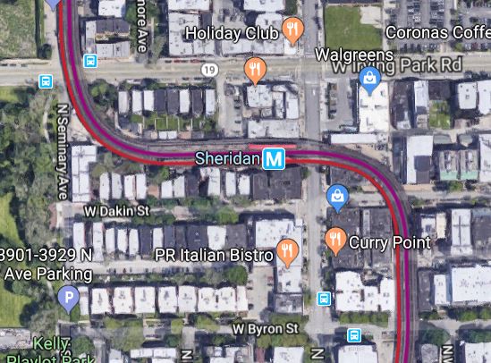
The Sheridan station's layout on an S-curve, surrounded by dense and valuable private property on all sides, makes any rehabilitation and realignment problematic. (Image: Google Maps satellite)
The Sheridan station is one of only two on an "S-curve", as seen above. Opened in 1900, this route and its sharp curves are a reflection of whatever right-of-way the private company that built it--the Northwestern Elevated Railroad--was able to acquire, without the public sector power of eminent domain. From the Northwestern's perspective, putting a station on the S-curve was probably seen as a great idea, as trains would have to traverse it at very low speed anyway.

Now, it will make for the CTA's most complex station renovation in recent memory. The existing platform width is not up to modern safety standards, let alone a width that would allow for elevators on both platforms, which would be compulsory as part of any rehab.

Widening platforms that are sandwiched between tracks means relocating those tracks, causing service disruptions presumably for multiple years, as well as expanding the overall right-of-way width. As you can see in the satellite image, the S-curve structure passes within inches of private property on all sides. Acquiring some or all of these properties would be expensive and controversial, and it still would only widen the S-curve, not straighten it out.

The cage-like stairs to the Sheridan platforms. (Image: Nandana N/Yelp)
Unfortunately, the alternatives do not look much better. One of the features for which the "L" is world-renowned, exemplified well by the north Red Line, is how many lines are so integrated within the physical fabric of urban neighborhoods. The Sheridan station in Lakeview East is no exception--virtually any attempt to straighten out this curve would demolish significantly more property than just expanding the current station on the S-curve.

The only other option would be a short subway between the Addison and Wilson stations, tunneling deep enough to avoid building foundations as it would not be following the street grid. This subway with one station (to replace Sheridan) would be less than a mile, yet it would still cost in the billions.

The bottom line is, as decrepit as it is, don't hold your breath on a Sheridan rebuild. And it is the complexity of the S-curve that makes this a real "all or nothing" situation, because it's nearly impossible to make any meaningful half-measure improvements in the meantime.

Clinton & LaSalle (Blue Line) 

LaSalle station. (Image: Cassandra Roman)
Most of the Blue Line's subway stations are nothing to write home about. Chicago Tribune transportation reporter Mary Wizniewski tabbed the tone of three of them as "transit noir" last year, citing an "oppressive, dank feeling."

Designed in the 1930s and opened in 1951, the main eight-station Blue Line subway travels from the Division station in Wicker Park, through downtown, and back west through the Clinton station in the West Loop. Most of these eight stations are criminal offenders--only the Clark/Lake and Jackson stations have truly been retrofitted to modern design standards and signage. But let's excuse Division, Chicago, and Grand, as the CTA's Your New Blue program just began significant renovations on those. In downtown, the Washington and Monroe stations are very busy and seem slightly better maintained.

This wonderful streetscape under the Eisenhower awaits you upon exiting Clinton. Heading to Union Station? You'll need to schlep a few blocks north. (Image: Timothy Hamlett)
That leaves us with LaSalle and Clinton. Gloomy, bland, and relatively deserted for much of the day, these aren't exactly the most Instagrammable of stations. They are the CTA's deepest rail stations, sunk over five stories underground due to crossing under the Chicago River between them. They also both feature long platforms with only one entrance, at the east end, so the eerily quiet western halves of the platforms feel like a subterranean tube of no man's land.

The LaSalle station is useful for connecting with Metra's LaSalle Street Station directly above, home of the busy Rock Island line to Joliet, but curiously there has never been a direct connection between the stations.

The deepest underground station in the "L" system, Clinton is also the only one exclusively accessible by escalator. (Image: Christian Wietholt)  
The Clinton station is nearly identical to LaSalle, but slightly deeper. Perhaps most damning is the laughably bad streetscape encountered upon exiting: you're directly underneath the Eisenhower Expressway (I-290), a dark and unpleasant place to be.

Clinton is sadly the CTA's strongest claim of a rail connection to Union Station, which is over two blocks away with no direct connection. That's a far cry from the direct subway connections found within the grand rail terminals of New York City, Washington DC, and even Los Angeles.

The upcoming Forest Park branch revamp includes plans for improving Clinton's usefulness. (Image: 2017 CTA Forest Park Vision Study)
When will Clinton and LaSalle, the two forgotten stations of the Blue Line subway, see some love? The CTA will soon be announcing their plans to revamp the Forest Park branch of the Blue Line, directly west of these stations. According to their preliminary Vision Study, it seems the project includes Clinton but not LaSalle. Let's hope they both get some funds somehow, from that project or a one-off.

Oak Park (Blue Line)

The Oak Park station is between the Eisenhower Expressway and freight rail tracks, in an open cut below the street grid.(Image: Hans Goeckner)
Speaking of stations along the Forest Park branch of the Blue Line, about eight miles west of Clinton we find the Oak Park station. The Forest Park branch travels almost entirely within the median of or alongside the Eisenhower as the two were built concurrently in the late 1950s.

Most station platforms on this branch are surprisingly narrow, especially given that the concurrent planning with the expressway means more space to them easily could have been devoted.

More problematic, though, is that like most expressway median transit stations, they are not pleasant to wait within (they are open to the elements and their soundtrack is that of the "expressway roar" variety) or walk to (expressway bridges, ramps, and general infrastructure are not generally pedestrian-friendly).

The Forest Park branch stations exacerbate this issue with long, skinny access ramps that connect stations with the street grid above. The theory was that instead of building stations under a major street for direct access, build stations in between two streets, with ramps up to both, thereby spreading walkable station access to more people.

The Pulaski station on the Forest Park branch epitomizes the "entrance ramp" concept that most stations on this branch utilized, with entrances stretching to streets on both ends via ramp. This approach's goal was to spread access to populations at both entrances, which would be at Pulaski Rd on the east side and Keeler Ave to the west. However, in this example, the Keeler entrance has been closed since 1973. (Image: Google Maps satellite)
The theory was well-intended and has some value, but the ramps are also somewhat self-defeating. The station platforms, as well as the aerial street bridges over the expressway, are already undesirable enough to walk. The ramps, which can intangibly feel a block long (even if they aren't really close to that), only add to that harsh, non transit-conducive experience.

Tangibly, the ramps add to the distance it takes to reach the platform (as opposed to just heading down a staircase from the street entrance), which limits the number of residents and businesses within any certain walkshed.

The Forest Park branch of the Blue Line, originally called the Congress line, was one of the first in the nation to feature stations in the median of an expressway, then considered an innovative idea. While such highway median stations have been built in a handful of other US cities since, the "double-sided access ramps" concept did not catch on. Even "L" lines later built in the medians of the Dan Ryan and Kennedy expressways did not feature entrance ramps.

Seen here from Google Street View, the East Ave entrance catwalk is an uncomfortable ground level walkway between the Blue Line platform and stairs to the East Ave bridge, between "L" tracks, freight tracks, and an expressway. (Image: Google Maps Street View)
The most damning "ramp entrance" of all is the Oak Park station's East Ave entrance. For reasons unknown (my guess is last-minute cost cutting), it's actually not a ramp at all. Instead, a fenced-in, track-level walkway leads 250 feet from the platform to a small staircase up to East Ave.

The infamous East Ave entrance catwalk at the Oak Park (Blue) station. (Image: zol87/Flickriver)
In this narrow catwalk, you are a pedestrian walking on ground level between two "L" tracks, which are sandwiched between an expressway and freight rail tracks. Not exactly a walk in the park.

How do we fix the "entrance ramps" and general unwalkability of these expressway transit stations? We will find out what the CTA has in mind when the project to renovate this line is finally announced soon.

Funding could be an entirely separate challenge. But for what's it's worth, the CTA has drawn up some transformative ideas in the Vision Study.


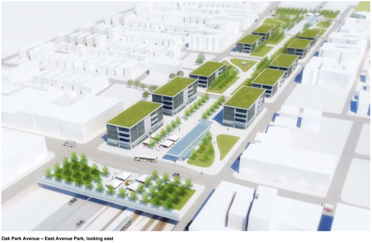
Urbanists, rejoice: the CTA's Forest Park Branch Vision Study proposes completely decking over the Eisenhower and Oak Park station, including both entrances. As preliminary as this is, it's good to such ambitious ideas in the realm. (Image: 2017 CTA Forest Park Vision Study)

Main & Dempster (Purple Line)

Dempster station on the Purple Line, which looks here in 2018 almost exactly how it did in 1910. (Image: Aaron Rogers)
These are just two of a handful of aging Evanston stations on the Purple Line. None of them are slated for improvements, but Main and Dempster are the oldest. They are remarkably unchanged since their 1910 reopening as elevated stations.

The same can mostly be said for Foster, Noyes, and Central, three other Purple Line stations further up the branch. But these three are remarkably unchanged since their elevation in 1930, making them a youthful 90 years untouched, compared to 110 for Main and Dempster.

Dempster and Main's station houses, which are very smiliar, truly feel like those of another time. (Image: Chicago Transit Authority)
Main and Dempster are two of the only remaining stations whose platforms are too short to hold eight-car trains. The Purple and its neighboring Yellow lines are the only two that still cannot run eight-car trains, which is a weekday standard on the CTA's busier lines and something the Purple would probably utilize if it could, given the crowding on its rush hour service to downtown Chicago.

Part of the reason for the lack of investment in these two stations has to be their lower ridership numbers. This makes them a lower priority, so much so that Dempster was one of 23 stations slated to close in 1991 due to a CTA budget crisis. However, the crisis was averted and Dempster stayed open.

The Main station's walkways to the platform. Of the CTA's 146 station rail system, this style is not seen anywhere other than these aging Purple Line stations. (Image: Jeremiah Cox/subwaynut.com)
The last real momentum to getting these stations some attention was when the CTA's 2004-08 Capital Improvement Plan designated funds for renovations of both. However, they did not follow through on the plan, and the stations remain unimproved. It remains to be seen what could create the momentum necessary for the CTA to devote capital funding to this branch.

Wednesday, September 11, 2019

3 Transformative Suburban Chicagoland Infrastructure Projects that Never Came To Be

Three unbuilt projects that would have drastically changed suburban communities, for better or for worse
The state-owned site of the proposed third Chicago airport in Peotone, Illinois. (Image: The Times of Northwest Indiana)

[This article originally appeared in The Real Deal Chicago.]

Highways, railroads, and other infrastructure often dictate where and how urban and suburban development occurs. Countless Chicago city neighborhoods and suburban downtowns were built around rail lines, followed by waves of development designed around cars and highways. Today, both continue to shape regional growth.

However, not all proposed infrastructure comes to pass. Some proposals are deemed not to be in the community’s best interest. Others are, but are derailed by politics, environmental hazards, or mismanaged finances, and are eventually forgotten to history.

The impacts they would’ve had–marshlands turned thriving suburbs, quiet towns turned traffic bonanzas–will never fully be known. Let’s take a look at three of the most impactful (good or bad) projects of the past 50 years that never saw the light of day in the Chicago suburbs.


Illinois Route 53 extension

The long-proposed extension of IL 53 (and an improved east-west IL 120), deep into northern Lake County. (Image: Daily Herald Business Ledger)

A hotly contested northern extension of expressway IL 53 from Palatine to Grayslake finally got the ax in July after decades of debate.

Proponents argued it would ease congestion and shorten commutes from the deep northern suburbs, while opponents pointed to major environmental concerns and an increased traffic burden.

Unrealized impacts: The deep northern suburbs are far more built out now than when this extension first hit the drawing board decades ago. Still, extending 53 easily could have pushed the new construction of many more suburban subdivisions, and accompanying congestion, into Lake County.


Metra STAR Line

Metra’s proposed STAR Line, connecting O’Hare with northwest suburbs, and then a run all the way down to Joliet.


The obvious drawback to Metra’s “hub-and-spoke” rail network is attempting to get anywhere not downtown, such as between suburbs, without having to come all the way downtown to switch trains. The late 20th century saw tremendous employment growth in the suburbs, and the  Metra network we know was poorly-equipped to serve it.

The STAR Line, Metra’s first circumferential line, would’ve helped. It was to use the I-90 expressway median and an existing rail corridor between O’Hare, Hoffman Estates, and Joliet, feeding existing Metra lines and linking countless suburbs to other suburbs.

Announced in 2003 and scheduled to be running by 2013, it was later cancelled as the cash-strapped agency struggled to make it through the recession.

Unrealized impacts: Post-recession, population growth in DuPage and Kane counties, through which STAR primarily would have run through, has become relatively stagnant. An investment such as STAR could have continued the previous growth. STAR’s route follows a handful of the few remaining undeveloped tracts of land in the western suburbs. Perhaps this could have resulted in suburban transit-oriented development–but, for the first time, with the suburban employee in mind.


South Suburban Airport

A site map of the proposed Peotone airport.

A third Chicago airport in Peotone, IL airport was first considered in the late 1960s, and has resurfaced regularly in the years since. The state has purchased much of the land that would be used, but otherwise has not made much progress.

While it may seem an unlikely scenario given the investments being made into O’Hare (namely an upcoming $8.5 billion “global terminal”) and Midway, this proposal has been back in the news this year with a new angle: cargo. The deep south suburbs have seen explosive growth in warehousing, logistics, and e-commerce fulfillment centers, which could lend a Peotone airport significant air cargo traffic.

Unrealized impacts: Peotone is firmly beyond the reaches of the south suburbs. That might not have been the case if it had been given a significant magnet for jobs and residents decades ago, which is what this airport could have represented. O’Hare and Midway may feel like unshakeable beasts, but it’s easy to forget that as recently as the late 70s, Midway barely had any commercial air service. Peotone, with expressway and planned express rail access to the city, could have dramatically shifted the south suburban landscape.

Monday, September 9, 2019

How Has CTA Ridership Fared in the 2010s?

A detailed, station-level and route-level look at CTA ridership post-recession provides interesting observations on the city as a whole

(Image: transitchicago.com)
The nationwide decline of transit ridership has been well documented. Steady years of hearty growth plateaud at 10.7 billion trips taken nationwide in 2014, which was up from 7.9 billion in 1996, according to the American Public Transportation Association (APTA).

While the declines vary greatly between metro areas, it is definitely a consistent trend across the United States. In 2017, Transit ridership fell in 31 of the US' 35 biggest metro areas and saw nearly a 3% decline in 2017. In 2018, the nationwide decline continued, this time closer to 2%.

It is not, however, a consistent worldwide trend. Yonah Freemark of The Transport Politic recently found that while US transit ridership saw an average decrease of 6% between 2010 and 2018, France transit ridership increased by a whopping average of 30%. After a small 2017 decline, even Canadian transit saw a 6% increase in 2018. 

Back in the US, many cities have seen an urban renaissance in recent decades. This has continued with a vengeance post-recession, with Census Bureau estimates finding 47 of the 50 biggest US cities saw an increase in population between 2010 and 2018.

Aesthetics? Pass. It may not look like much, but the Washington station on the Blue Line saw 68% weekday ridership growth  between 2010 and 2018, easily the highest in the system. (Image: Medill Reports Chicago)
It is interesting, then, that transit ridership's decrease has continued even while its available market of residents, at least theoretically, has increased. This means transit ridership per capita has decreased even more significantly, and there are a handful of reasons why.

Chicago is a prime example of this population growth/ridership shrink paradox. The CTA's total ridership decreased from roughly 517 million in 2010 to 468 million in 2018, a decrease of over 9%. In the same time, the city's overall population has increased, albeit very slightly. 

More significantly, however, is that many of the city's densest, most transit-rich areas near the city center, where there are more CTA lines serving more destinations available than anywhere else, have seen some of the sharpest population spikes. Between 2010 and 2017, huge population influxes have occurred in the Loop (+22%), Near West Side (+15%), Near North Side (+10%), and Near South Side (+10%). What gives?

The Morgan station on the Green and Pink Lines, a vital cog in the development of the burgeoning Fulton Market District, saw 30% weekday ridership growth even in the "ridehail era" between 2015 and 2018. (Image: David Wilson)
Of course, with all the mobility alternatives available today, it is no longer a given that people moving into a transit-rich area will use transit at all. One of the most cited reasons for the nationwide transit decline is the advent of ridehailing services such as Uber and Lyft. While these services were initially promoted primarily as transit-complementary services, providing last-mile connections and a better alternative in "transit deserts", a trip data release from the companies earlier this year revealed that hasn't been the case. 

Transportation planner and advocate Steven Vance found the most common Chicago ridehail trip to be between the western part of River North and the Loop. The Brown Line directly serves this trip as well. The second-most common trip was between the "Loop West" and O'Hare, which is directly served by the Blue Line, and the third-most common was literally within the greater Loop (classified informally as Loop West and Loop Northeast). 

Clearly, lack of available transit options was not the impetus behind these trips, and higher budget elasticity among the higher average incomes in these areas can support far more Ubers.

Some of the other most commonly cited factors for the nationwide transit ridership decline have been increasing congestion in cities, which can make bus, streetcar, and light rail service especially slow and unreliable, lower gas prices, increased rates of car ownership, and the ever-dangerous transit "death spiral". The death spiral is that as transit ridership decreases, service is reduced, making the experience less convenient for riders who remain. This causes a further decrease, causing more service cuts, and so on.

Still the busiest bus line in Chicago by a comfortable margin, the #79 79th St bus has still hemorrhaged riders since 2010. Investment will need to be made in this route, and the communities it serves, to get it back on track. (Image: Lee Edwards/Block Club Chicago)
Thankfully, here in Chicago the transit decreases have not been as severe in proportion to those in other cities, even if a 9% decrease is enough to have local officials worried.

But such a broad statistic doesn't tell us much about what's happening where in the city. And given the city's current drastically diverging plotlines--simultaneous explosive growth in population and income in some areas, such as the West Loop and River North, and continued depopulation and disinvestment in others, such as Englewood and West Englewood--it's worth a closer look. What conclusions can we draw from CTA growth and decline data across the city?

The CTA releases monthly ridership reports, and has published a cumulative year-end report since 2010. The 2018 year-end report was just released, and I've put it and the previous years' into a better way to synthesize over multiple years. The screenshots below include some insightful trends.

The year-end reports frequently mentioned here are from 2010 and 2018, the bookends of the comparative annual data, as well as 2015, which was a recent peak year for the CTA at about 1,641,000 average weekday riders. Rail ridership hit an all-time peak of 768,000 that year and has declined since. Bus ridership had actually already been declining slightly, but the decline almost completely leveled off in 2015 at about 873,000 per weekday. 

2015 is also a notable barometer as it was one of the biggest growth years of Uber and Lyft into the mainstream Chicago marketplace, so the 2015-18 comparison is truly a look at ridership growth or decline within the "ridehail era".

Busiest CTA rail stations in 2010 and 2018 weekday ridership. Each station's text color in these tables represents which line it serves. If it serves more than one line, the text is black.
First, a look at the busiest CTA rail stations at beginning and end of this time period. Clark/Lake, which had been the busiest station for some time, was dethroned by Lake (Red) in 2014, which has been the busiest station each year since. 

In case you're curious, Kostner on the Pink Line has been the least-busy station since at least 2010, at less than 500 riders per weekday most years.

Note the spike from #15 to #4 for Washington (Blue), a significant drop for 95th, and a near flip-flop for Washington/Wabash and State/Lake--more on this later. Also, while the Washington/Wabash station didn't open until 2017, for sake of data comparison, its pre-2017 data consists of a combination between Randolph/Wabash and Madison/Wabash, the two stations it replaced.  

(A somewhat misleading data caveat--note that the subway station Lake (Red) is technically counted separately from the elevated State/Lake even though they're mere steps from each other, while the Clark/Lake total combines entrances for both its subway Blue Line platform and elevated Loop platform. If State/Lake and Lake (Red) were also combined, its 2018 weekday ridership of 33,677 would blow all other stations out of the water.)  

Fastest-growing CTA rail stations between 2010 and 2018, and between 2015 and 2018, in weekday ridership. Between 2010 and 2018, 95 of 140 comparable rail stations saw growth, compared to just 31 of 142 between 2015 and 2018.
Now, the fastest-growing rail stations, first between 2010 and 2018. Note that eight of these 15 stations are on the Blue Line, including all of the top five. All of them, however, are in its downtown subway or on the O'Hare Branch to the northwest. This won't come as a surprise to Blue Line riders--overcrowding on this line, which runs through some of the densest and fastest-gentrifying neighborhoods in the city, has been in the news regularly. Otherwise, six of these stations are served by the Brown Line.

Between 2015 and 2018, which we're calling the ridehail era, growth was led by a pair of brand new development-oriented infill stations on the Green Line, Cermak-McCormick Place and Morgan (however, note that Cermak's true increase would not have been 45%--the station was not open the entire year of 2015, so its weekday ridership average that year was artificially low). 

Washington (Blue) and Monroe (Blue) continued their fervent growth, which is clearly a by-product of being main downtown destinations for those new riders on the Blue Line's O'Hare Branch. Don't look now, but little-known Noyes on the Purple Line, one of two stations that serves Northwestern University came in at #6 for 2015-18 growth, although at only 98 riders added, it clearly operates on a different scale than most others on this list. 
Fastest-declining CTA rail stations between 2010 and 2018, and between 2015 and 2018, weekday ridership.


Next we have the biggest decreases in the CTA rail system. Between 2010 and 2018, we find an alarming drop along the Green Line, both on the West and South Sides, and on the South Side Red Line. The steep drops at the Green Line's Halsted (& 63rd) and Ashland/63rd are consistent with the continued struggles of Englewood and West Englewood, which have lost over 11,000 residents since 2010 alone

Despite a brutal drop 25% drop of over 3,000 riders, it will be interesting to monitor 95th on the Red Line going forward, as the CTA just finished the biggest station improvement project in city history there. The modern digs should make for a much improved customer experience, and the CTA is now even looking to fill eight adjacent parcels to the station with transit-oriented development. The surrounding Roseland community surely could benefit from such investment.

Between 2015 and 2018, the top decline came at the Blue Line's IMD station, although a station reconstruction project threw off its 2018 ridership number should have been. Otherwise, we find even more alarming declines on the Green Line, South and West Sides.

Busiest CTA bus lines in 2010 and 2018 by weekday ridership.
Moving over to the bus side of the CTA, we find a fairly consistent group of lines topping the charts between 2010 and 2018. There is a consistent, palpable decline, however, across almost all lines. A couple of these have an excuse--the #9 Ashland and #49 Western dropped significantly because new complementary express lines were introduced on those streets in 2016, siphoning off a number of their riders. 

The #79 79th, however, has no such excuse--a straight drop from 32,000 to less than 24,000 in 2018. And yet, shockingly, that 27% drop of over 8,500 riders did not even make the top 15 in bus route declines, as we'll see in the next graphic.

Fastest-declining CTA bus routes between 2010 and 2018, and between 2015 and 2018, in weekday ridership. Between 2010 and 2018, 105 of 120 bus routes declined in weekday ridership, and 108 of 123 between 2015 and 2018.

Here's where things get tricky. Three of the top four on the 2010-18 decline list are contracted CTA routes funded by third parties, so they are limited services benefitting those entitites (in this case, #X98 for Avon, #169 for UPS, and #10 for the Museum of Science & Industry). The #11 Lincoln had a majority of its route cut in 2012, so no surprise there. And the next two are special event services for Soldier Field (#128) and the United Center (#19), which also vary greatly for reasons out of the CTA or city's control.

We'll also want to disregard the #9 and #49, due to the aforementioned express lines. Of the seven remaining routes, all but one exclusively serve the South Side.

Between 2015 and 2018, we find a similar story. Excluding the same lines as before, nine of the ten remaining lines serve the South Side.

There isn't much to write home about on the bus side of things in each time period. Between 2010 and 2018, and between 2015 and 2018, only 15 comparable bus routes saw weekday ridership increases. Perhaps most notable are a pair of South Side express services: the #26 South Shore Express (a 52% increase between 2010 and 2018) and #2 Hyde Park Express (a 33% increase). 

Could it be because these are much more competitive services than your average milk-run local bus? Quite possibly. But a similar service in the #6 Jackson Park Express has seen sharp declines, so your guess is as good as mine.

Feel free to find your own line and station to hypothesize about it in the context of the city: here's the spreadsheet all of this comes from, which is data directly from the CTA's reports. 

Access to opportunity is paramount for the economic vitality of the city across all demographic groups. Transit, in the form of CTA buses and trains, happens the be the most efficient way to achieve that for a city the size of Chicago. The good news is, especially if Canada and France are any indication, this doesn't have to be a permanent trend. Solutions are aplenty, but they'll take political will and capital. Mayor Lori Lightfoot has her work cut out for her.

Sunday, September 1, 2019

The Case Against One Central's Transportation "Hub"

Aesthetically, the One Central transit hub looks arguably more spectacular than any other rail terminal in the United States. Now, if only it were actually necessary.
(Image: Landmark Development)
Hunting for a fortune in public funding, Landmark Development is touting that its proposed One Central development in Chicago's South Loop includes a "world class" transit hub. Except that there's no need for a "hub" in that location, and most attempts to create one would create far more problems than solutions.

Earlier this year, Landmark Development unveiled a proposal for the next Chicago megadevelopment. The humongous South Loop plan would stretch above the Metra Electric tracks from Roosevelt Road to McCormick Place, nearly a mile long, with numerous skyscrapers and public green spaces.

Curiously, the project was also announced with a specific intention to create a new transportation "hub", complete with fancy renderings of a terminal you'd expect to find in France or Germany. Not that anything about a grand rail terminal in general is bad, but a quick analysis of this one finds this "hub" to be completely nonsensical.

One Central's "world class transit hub". (Image: Landmark Development)

Why the emphasis on the "hub" then, instead of just focusing on the main components of their project? Because if they can convince local officials that this megadevelopment is truly in the public interest, via a regional transportation hub, it could unlock billions in city and state dollars and tax breaks. This is especially key for Landmark seeing as the the funding plan for One Central does not include any TIFs, unlike the controversial Lincoln Yards, which was approved despite intense scrutiny on its heavy TIF reliance.

The One Central transportation hub is slated to feature:

  • an "extension" of the CTA Orange Line
  • an "extension" of the Metra BNSF Line
  • a new infill station along the Metra Electric Line and South Shore Line, which already runs directly beneath the project area and already has an old station at 18th St
  • a new Amtrak "hub"
  • a bus line (the "CHI Line") between One Central and Millenium Park

"Extension" is in quotes because for both the Orange Line and BNSF, it's not actually an "extension" that has been proposed, it's a branch. This is a crucial differentiation if we're talking about transit that's actually useful for people, and in both cases, branching would cause many more problems than it would solve.

Similarly, a "hub" is defined as "an effective center of a network," and One Central would not be that.

The One Central plan is heavily reliant on a significant mode shift to transit. However, even if their transit plans were efficient, a 60% increase in transit mode share would be a shockingly dramatic shift. Also, the "current" numbers seem to be completely fabricated: per 2017 CMAP data, the Near South Side's current mode split is actually 47% "drive alone", 28% transit, and 14% walk or bike.

This is a classic example of a developer either A) not understanding transportation dynamics and putting forth a nonsensical, yet gleaming, idea, or B) understanding how nonsensical it is and promoting it anyway, because they're betting that politicians won't know the difference.

Furthermore, even if a politician does see flaws in the plan, they almost certainly have political stake in the project other than "efficient, dynamic transportation infrastructure," so they're often unlikely to blow the whistle and risk the entire project falling apart.

The imaginative idea of this "hub" is the developer's best (and probably only) path towards hundreds of millions of public dollars, so a "hub" it is.

(Image: Landmark Development)
To Chicago Mayor Lori Lightfoot's credit, she has highly skeptical of the hub proposal, openly criticizing it multiple times in June. Even when asked if her opposition was more of a "how" instead of an "if" the project would happen, she said, "No, I think I've just said, I have questions as to whether or not we need a transportation hub."

She had also dismissed its necessity in saying the city has "huge transportation needs all over the city," specifically naming the Red Line extension to 130th St as an example of a much higher priority.

Lightfoot is right to be skeptical. The case for the hub does need to be made, and nearly three months since those comments, Landmark still hasn't made one.

A possible reason why? There isn't much of a case to be made. Breaking it down by each component, it quickly becomes apparent that this hub would be built on a foundation of poor transportation planning.

Orange Line branch

A rough projection of the branch's route, which would need to be elevated and constructed from scratch.
As the Orange Line leaves the Loop heading southbound, it runs along Wabash to around 18th, then veers curves west towards Midway. Here, goes the thinking, you could build a spur from 18th/Wabash eastbound along 18th over to One Central, and run some Orange Line trains that way too. However you slice it though, this solution creates an avalanche of other problems:
  • Branching the line halves train frequency. By branching the Orange Line two ways, you automatically cut service in half on each branch. That would mean Orange Line trains leaving downtown must alternate between Southwest Side/Midway trains and One Central trains. 
    • Currently, Orange Line trains leave downtown for Midway every 7.5 minutes at rush hour and every nine minutes at midday. With the branching, that would be every 15 minutes at rush hour and 18 minutes midday on each branch, which is completely unacceptable on the Midway branch because of its capacity demands. 
    • Infrequent service also kills ridership, and this would instantly make the Orange Line the least useful of the CTA's lines.
    • As if Mayor Lightfoot didn't already have enough reasons to dislike this proposal, the optics of slashing half of the rail service to low and middle-income Southwest Side neighborhoods (as well as Midway), in exchange for service to another controversial central city megadevelopment, would be horrible. Southwest Side residents would be less than pleased.
  • One Central trains would be just as infrequent. Would some people board the trains to One Central? Sure. But because of the branching, these trains would also be capped at once every 15 minutes at rush hour, and less than that in off-peak times. That won't cut it, especially if One Central draws a fraction of the employees and residents advertised.
  • Loop track capacity constraints don't allow adding more trains. The obvious question here is: why can't they just run more Orange Line trains, on both branches? The Orange Line uses the Inner Loop (clockwise) track downtown, which is also used by the Pink, Green, and Purple. It's at maximum capacity--you can't add trains on any of those lines without decreasing service on another, and the Orange Line already has more service than any of those three because its heavy ridership warrants it.
Bottom line: The physical realities of branching rapid transit lines provides unacceptable Orange Line frequencies for both the Southwest Side/Midway and One Central at best, and at worst, a PR disaster for Lightfoot pitting working class commuters against mega-development yuppies.

Metra BNSF branch

A rough projection of the branch's route, using existing little-used freight tracks.

The BNSF Line runs from Aurora to Union Station. Coming eastward into the city, it runs adjacent to 16th St and curves northward just past Canal St, where it goes right into Union.

There are also existing railroad tracks that don't curve northward, but rather continue east through the South Loop all the way to the lakefront, connecting with the Metra Electric Line and freight tracks near Soldier Field. These tracks are how the BNSF would theoretically access One Central. But even with the existing tracks (which minimizes capital costs for this idea), branching the BNSF makes even less sense than the Orange Line:
  • Exacerbated BNSF Line capacity issues. The BNSF is by far Metra's busiest line, and it runs along the busiest rail corridor (Metra, freight trains, and Amtrak combined) in America's rail capital. Unsurprisingly, the BNSF already struggles with capacity, and any rush hour trains routed to One Central are now trains that no longer serve Union Station. This is a major problem, because the vast majority of riders are, and always will be, going to/from Union. Even if One Central winds up employing 10,000 people, which would be a significant accomplishment, downtown Chicago will still be employing 650,000.
  • No ability to transfer from other Metra lines. While you can (inconveniently) transfer between Metra lines downtown, downtown transfers from other Metra lines would actually be impossible in this scenario. That rail link between the BNSF and the Soldier Field area comes in from the west, meaning One Central trains wouldn't stop at Union, or any of the other three downtown Metra terminals. This means that the BNSF branch would literally only be useful for people who live along the BNSF line, and almost completely useless for city residents.
  • Little, if any, off-peak service. So we know that western suburbanites along the BNSF could commute in to One Central for the 9-to-5 workday, and there would probably be probably be sufficient demand induced to designate a few rush hour trains to go there (setting aside the problems this would create for Union Station commuters). But outside of rush hour, most Metra lines run only every hour or two to downtown, and some don't operate at all. Given that, it would be hard to see them justifying off-peak or weekend trains to One Central at all, because without a serious infusion of operating funds to run more trains, you'll still be taking away crowded Union Station trains.
Bottom line: For a limited suburban commuter population (those living along the BNSF in the western suburbs), this would help the 9-to-5 crowd get directly to their One Central jobs, at the expense of all other BNSF riders. But like most other modern day mixed-use developments looking to maximize their square footage, One Central will certainly be designed for people to live, work, and play. Relying on a branch of one Metra line that only serves 9-to-5 commuters from the western suburbs as a serious mobility option would be counterproductive to that goal.

Metra Electric/South Shore infill station

Seeing as One Central is already along the Metra Electric line, a new intermediate station at One Central--which basically just replaces the aging 18th St station--makes sense. Not shown on this map is the South Shore Line, which could also utilize it. (Original image: TransitCenter)
Finally, an idea that makes sense, even if its scope is pretty narrow. The Metra Electric line, which runs between Millenium Park and University Park in the deep south suburbs, runs right thru the proposed project area--the project will deck over the Metra Electric's yard and maintenance facility across from Soldier Field. The South Shore Line also uses these tracks to get out of the city towards Indiana, and could stop at One Central on the way.
  • This station would benefit Metra Electric and South Shore Line commuters. You could easily build a station at One Central to serve the Metra Electric and South Shore. 
    • However, just as with the BNSF, the only commuters that would benefit would be those near South Side and south suburban Metra Electric stations, and northwest Indiana South Shore stations. 
    • So the scope is limited, but it does help that these two lines in particular would provide a lot more communities with direct access: the Metra Electric is comprised of three branches that spread out across the South Side, and the South Shore Line will soon be constructing a second branch of their own in Indiana.
  • You could also use the station to access One Central heading southbound (from downtown), but Metra's schedules and fares structure would need to be improved to make this convenient. The Metra Electric reverse commute morning schedule has random gaps of 15-30 minutes in it, so transferring from other modes in the Loop to Metra Electric wouldn't be all that convenient. 
    • That's not even mentioning that Metra's fares still don't integrate with the CTA's, so even the short trip from Millenium to basically Soldier Field would cost $4 each way.
    • South Shore Line trains aren't even permitted to carry passengers between stations within the Metra Electric corridor, so as to avoid competing with Metra.
  • This station already exists. There already is a Metra Electric station basically right there--at 18th St--and it serves a whopping 23 riders every weekday.

Bottom line: Obviously weekday ridership would greatly increase from 23 with One Central's construction, but because of the prior points, its total scope would always be limited. And nothing about one improved station on an existing line constitutes a "hub".

Amtrak station

A map of the Amtrak lines running into Chicago, which all converge upon its hub at Union Station. Of the 60 daily Amtrak trains using these lines, only 6 utilize the track that passes One Central, and it would out of the way to send any of the other 54 there.

Chicago Union Station is Amtrak's fourth-busiest station nationwide, and its busiest off the Northeast Corridor. I'd be shocked if they had any interest at all in One Central, for numerous reasons:
  • Why would Amtrak want to de-centralize Chicago operations? Managing a massive intercity passenger rail network, it is to Amtrak's advantage to keep their operations in each individual major city as centralized as possible. Their fixed station costs, for everything from station personnel to engineers to checked baggage services are most efficiently kept at one terminal.
    • This is especially true at Chicago Union Station, which sees Amtrak trains departing in seemingly every direction. No trains run through Chicago, so any Amtrak passengers traveling through have to connect to their new train here. This means Union Station actually is an important "hub", much like how airlines use hubs for connecting flights.
  • Union Station boasts unbeatable proximity to Amtrak's locomotive and coach maintenance facility. All Amtrak trains terminating in Chicago are serviced and stored here between revenue runs. That proximity to Union Station is part of what makes Union ideally equipped as a terminal for everything from a three-coach regional train to a long-distance behemoth. 
  • Amtrak owns Union Station, and is spending unprecedented refurbishment and expansion dollars on it. Amtrak is spending hundreds of millions to reopen disused areas, as well as leading a big mixed-use expansion project. It is probably the biggest capital investment in Union from anyone, government or private railroad, in at least 50 years.
  • Union Station is in a far more central location for an intercity hub than One Central, both in the context of the city and connecting to local transportation.
  • Railroad operations challenges make accessing One Central illogical, if not simply impossible, for most of Amtrak's Chicago trains.
    • Of the 60 Amtrak trains that run in or out of Chicago daily, 6 currently utilize that track that runs between the Soldier Field/One Central area and just south of Union Station, the one I mentioned that the BNSF line branch would theoretically use. These 6 Amtrak trains are the one daily train to New Orleans and two daily trains to Carbondale, all via Kankakee and Champaign. These trains could easily stop at One Central, as it would already be on the way. 
    • As for the 54 other daily Amtrak trains, they would literally all have to be rerouted to One Central before or after Union, either going out of their way (if possible) to get on the lakefront freight tracks or, after stopping at Union, reversing out to One Central. Only to come right back towards Union to the maintenance facility.
    • For example, the popular Detroit-Chicago trains do enter Chicago through the South Side, but they take a route farther west than the tracks that pass One Central. There is no track connection on the South Side between its current route and the lakefront One Central tracks, so they would have to come in to Union, reverse out and use the connecting track, terminate at One Central, then basically come back to Union for maintenance.
Bottom line: A logistical nightmare that would hardly benefit anyone's Amtrak travel plans, and certainly not Amtrak's existing hub. As for the 6 daily trains that already pass the One Central site, they could certainly serve One Central without much issue.

You know, right before they get to Union Station, which is where everyone on the train will be going anyway.

CHI Line Bus

Confusingly, despite reports claiming the CHI Line would utilize the McCormick Place Busway, Landmark's own presentation seems to show it just using surface streets.

We don't know much about this idea, other than it's some sort of "circulator" that supposedly would utilize the existing McCormick Place Busway with autonomous vehicles between Museum Campus and Millenium Park, somehow continuing to Navy Pier.

The Busway, which is currently open only to convention-chartered buses and other vehicles with specific access, is one of Chicago's most underutilized pieces of transportation infrastructure. The CHI Line would fix that--but it's also not like the city couldn't do the same thing on its own, with or without this development. It's not even clear who would be responsible for operating the CHI Line, be it the CTA or a private service.

Regardless, the CHI Line has some value in the context of One Central. It could be a high frequency and dependably fast link between East Loop "L" stations and One Central.

However, it doesn't do much for the thousands of One Central employees that would be arriving via Union Station and Ogilvie.

This is all assuming the CHI Line actually uses a direct route via the Busway, which is unclear as Landmark's own project transit map (see above) seems to imply it will instead meander around on congested surface streets. Unless it involves some sort of dedicated lanes on these streets (consider this unlikely), it's no improvement at all over existing CTA bus service in the area.

If anything, a development proposal such as One Central should underscore the need for better traffic-separated central area circulation, specifically to better serve areas surrounding the Loop. A high capacity transit line between Museum Campus/South Loop, West Loop (including Union and Ogilvie), and River North/Navy Pier is absolutely needed. The CHI Line isn't that, but it could be.

The idea last received significant momentum in the mid-1990s when Mayor Daley pushed it, known as the Chicago Central Area Circulator project, but Governor Jim Edgar didn't sign off and the proposal died. A group brought it back in 2016, but without a high profile champion, it died again.

~~~

After observing that of all these grand ideas, only the CHI Line (if it does use the Busway) and improving the 18th St Metra station would actually be beneficial, we're certainly not left with a "hub".

It's time for Landmark to give up the naive-at-best, disingenous-at-worst transportation hub angle, and have One Central be fairly evaluated in terms of its actual positive and negative impacts on the economy and community.

(Image: Landmark Development)
Regardless of whether or not One Central happens, there are two things we know for sure. The McCormick Place Busway (the route of the proposed "CHI Line") can and should be much better utilized for transit, and a Central Area Circulator connecting the West Loop, South Loop, and River North is vital for future growth of the urban core.

If One Central passes its actual, non-transit hub judgment, the developers must be leveraged into contributions to one or both of these plans. It's the least they could do to manage the transportation demand they'd be creating, not to mention making meaningful positive impact for the existing South Loop community.

Saturday, August 31, 2019

The CTA's Secret 9th Line: The Brownge Line

How the CTA and Metra each operate a color-changing rail line every day, unbeknownst to almost anyone who doesn't utilize them regularly

Looks like an Orange Line? Maybe not. (Image: Jeremiah Cox/subwaynut.com)
The actual name of the Chicago Transit Authority’s secret train line is still up for debate. Other candidates include “Brorange”, "Orangown", or hopefully a more appealing combination of “brown” and “orange” you can devise.

Its existence, meanwhile, is an operational fact, even if it's not marketed as such. As you might be able to tell by now, the line is a combination of the Brown and Orange Lines.

Unless you’re an early morning Orange Line commuter, morning Brown Line commuter, or have a insatiable desire for random CTA knowledge similar to this writer's, you’re probably unfamiliar with the unbeloved Brownge.

Current weekday Orange Line schedule. Note the six trips marked “K” for  Kimball-bound (the Brown Line’s terminus), exposing them as Brownge.
Six Brownge trains run every weekday, each departing from Midway Airport between 6:00 and 6:49am. They masquerade as normal Orange Line trains to the Loop. There, they suddenly become Brown Line trains and, instead of looping around and heading back to Midway, only complete half of the Loop before heading north along the Brown Line.

Current Brown Line weekday schedule. Note the subsequent six trips marked  “M” for Midway-bound, the southbound return of the Brownges.
They reach the end of the Brown Line at Kimball, where they turn around and start a new Brown Line run to downtown. These depart Kimball between 7:23 and 8:13am. Upon entry to the Loop, however, they again turn Orange, and exit the Loop prematurely to head south to Midway Airport. This pattern does not repeat during the evening rush.

Believe it. CTA’s nine true lines consist of Red, Blue, Brown, Orange, Green, Pink, Purple, Yellow, and Brownge.

Its existence is due to creative problem-solving by service planners at the CTA. It became necessary due to exploding Brown Line ridership in the 1990s and 2000s, which sparked the 2006–09 Brown Line Capacity Expansion Project. The project completely rebuilt 16 of the line’s 19 non-Loop stations to bring them up to modern standards--the entire line was built in 1907 or earlier, and many stations hadn’t seen major investment since.

It also extended platform lengths to run 8-car trains, which hadn’t ever been possible on the Brown Line. The CTA’s other most congested lines, the Red and Blue, had sworn by 8-car trains for years. The first 8-car Brown Line trains started running in March 2008, significantly increasing capacity.

But it still wasn’t enough to keep up with demand. And the CTA couldn’t run any more trains because the schedule had already maxed out the available cars at Kimball Yard, a relatively tiny plot of land that houses Brown Line trains amidst a dense residential Albany Park.

The only option left for the CTA was to pull trains from another line’s yard each day and send them up the Brown Line, and the Orange Line was a natural fit. Not only did the Orange’s Midway Yard have excess capacity, the two lines are operationally similar in length (Brown, 11.4 miles; Orange, 12.5 miles) and run time (around 30 minutes each way), and already entered the Loop on opposite ends, so the transition would be relatively natural. If anything, they almost appear to be North and South Side counterparts on the system map.

The CTA’s Brown and Orange Lines run remarkably complementary routes on  the city’s northwest and southwest sides, respectively, making them a natural fit to merge for a limited number of morning rush hour trains.
Hence, the birth of the Brownge Line, likely circa 2009. It represents the only through North Side-South Side service other than the Red Line. Between the six northbound surplus-capacity Orange Line runs and six southbound max-capacity Brown Line runs, it’s entirely possible these trains are serving 3,000–5,000 riders per day. That places it not far behind the Yellow Line’s average ridership for an entire weekday.

The CTA does not outwardly mention the existence of these trains, probably so as to avoid confusion, but they are well-equipped in communicating them. CTA’s Train Tracker displays on the platforms and your electronic device of choice do a great job of denoting trains as “Loop, Midway” or “Loop, Kimball” trains.

The trains themselves cannot do this, however. Train operators do announce its imminent color change as the trains prepare to enter the Loop, giving the unenlightened an opportunity to get off and wait for a monochrome train. The only other thing operators can do is to mark their train’s final destination much earlier, which seems to be happening more often recently. This has the benefit of alerting those in the know, although completely befuddling everyone else.

Imagine a southbound train marked as a Midway-bound Orange Line pulling into Southport Brown Line station during morning rush hour. If you’ve been acquainted with the Brownge, you’ll board it confidently. If not, you’re wondering, is this an erroneously marked train, a schmetically misguided train, an out of service train, or a ghost train?

You weren’t expecting this spooky scene on your morning commute. You were just hoping to get downtown early enough to stop at Do-Rite Donuts before your morning meeting. The uninformed must choose between waiting for the next Brown Line and possibly forgoing the double chocolate glazed, or gambling with the transit gods in hoping this train will get them where they’re going.

The CTA leveraging its rail infrastructure in unique ways is nothing new, however, and it’s important to differentiate the Brownge Line. Whether due to planned maintenance work, capital projects, or service disruptions, the agency (as with any transit agency of its size worldwide) has a long history of temporary line reroutes or cuts. If it's for planned work, these take place primarily on evenings and weekends so as to inconvenience less riders. Some recent reroute patterns include:
  • Sending Red Line trains “up top” in bypassing the State St Subway for the elevated tracks, through the Loop, between Chinatown and Lincoln Park
  • Sending Red Line trains down the Green Line elevated on the South Side, done for the Red Line South’s 2013 complete reconstruction and again over the last few years for the new 95th St terminal construction
  • Closing one half of the Loop on a weekend, rerouting numerous lines
  • Sending Pink Line trains onto the Blue in the median of the Eisenhower Expressway, as a shuttle service to connect with the Blue for downtown service
However, all of these are temporary service patterns designed out of system maintenance or improvement, or disruption minimization. The mighty Brownge, however, was designed out of capacity constraints to maximize efficiency in regular weekday service. That it has done thanklessly for nearly a decade now, and perhaps years to come. And yet its name (publicly, there isn’t one), or existence, will remain unknown even to many of its regular users.

Not to be outdone, Chicago commuter railroad Metra features a secret line of its own, in addition to the 11 it normally operates. By “line”, in this case we’re looking at just a single weekday train, in one direction.

The train in question begins on Metra’s North Central Service (NCS) line, its second-least patronized line with under 6,000 riders daily. (Metra’s busiest, the BNSF Line to Aurora, serves over ten times as many.) However, the NCS provides 10 valuable weekday-only roundtrips from and to Antioch, Illinois, a 14,000-resident suburb which borders Wisconsin and is literally closer to downtown Milwaukee than downtown Chicago.

The standard 52.9-mile trip from Antioch to Union Station takes 1 hour and 35 minutes. The trains run south through Rosemont just east of O’Hare before merging with the much busier Milwaukee District-West (MD-W) Line at Franklin Park, turning east toward downtown. NCS trains skip a number of lightly-used Metra stations in the city, but on the longer, suburban portion, almost all trains make all stops. North of O’Hare, no stops at all are skipped. The lack of traditional Metra express train service is likely directly correlated to the lower total number of trips that serve this route.

However, the last train of the night out of Antioch, #120 departing at 7:02pm, makes the run into downtown in 1 hour, 16 minutes, without running express on the NCS. How?
Note the crossover between the dark purple (NCS) and dark red-orange (MD-N) lines near Grayslake. That’s Prairie Crossing, and it allows one southbound  NCS train to turn into an MD-N train every weeknight.
It accomplishes this by completely leaving the NCS line for the Milwaukee District-North (MD-N) line, via a crossing in Libertyville. It then does run express to Union Station, stopping in Libertyville and Lake Forest before skipping 13 MD-N stations.
The inbound weekday evening NCS timetable,
displaying final train #120 seeming to run
express from Washington St in Grayslake
at 7:16pm to Union Station at 8:18pm.
However, the asterisks reveal the train
switches to the MD-N line.
The inbound weekday evening MD-N timetable, displaying a phantom #120 train that seems to appear out of thin air at 7:33pm in Libertyville. However, see those tiny NCS letters above the train number? That’s how we know it’s the same train.
It is unknown to this writer exactly why this train makes the abrupt line shift, or when this practice began. It could be due to limitations in Metra’s trackage rights agreement with Canadian National Railway, the railroad from which Metra rents track space on the NCS.

The most likely scenario, however, seems to be high demand Metra had recognized for a reverse-commute evening express from Libertyville and Lake Forest. Earlier this year, Metra added even more reverse commute service to the MD-N, partially funded by a highly-motivated Lake County economic development group. Bumping one train over from the NCS may be an easy way to assist with this service.

Metra North Central Service train #120, the last inbound train of the night, at Lake Villa. In just a few miles at Prairie Crossing in Libertyville, it will switch to the Milwaukee District-North line and run express to downtown.
Even if we don't know the exact reason for its existence, what we do know is that naming this service is a lot less fun. Introducing the "North Central Milwaukee District-North" line? The "Milwaukee District-North Central" line?

Let’s just go with the Antioch Express, seeing as it is the only true express train on the NCS. And for that presumably limited number of reverse commuters from Antioch, Lake Villa, Round Lake Beach, Grayslake, Libertyville, and Lake Forest that benefit from it, bully for you.

Thus, the Brownge Line and the Antioch Express. You’ll never see those names on a timetable, but if you know when and where to look, you’ll find them in operation, each and every weekday. Even if you don’t know where to look, if you commute on the Brown, Orange, NCS, or MD-N lines, watch your train’s path closely--you might just be on one.